
Board Spotlight: Community Geographic Information System Program for Local Municipalities in New York
By: Richard Zink, Executive Director, Southern Tier West Regional Planning and Development Board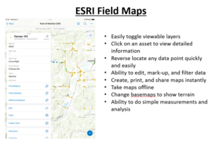
In 2023, Southern Tier West (STW) launched the Community Geographic Information System (CGIS) program to help local municipalities manage and use geographic information effectively. They used advanced ESRI software to provide powerful mapping and data analysis tools to municipalities in the region.
The program’s core is ESRI’s ARCGIS Online, a cloud-based system that allows seamless collaboration and data sharing among municipalities. STW secured a Small Enterprise Agreement Local Government-Based license, enabling 50 municipalities to use ARCGIS Online. To make it accessible, STW resold these licenses to municipalities, reducing the financial burden.
Each ARCGIS Online license includes 50 creator accounts for making maps, 50 viewer accounts for accessing data, and 50 licenses for ARCGIS Desktop Advanced or Standard. STW also created 15 customizable surveys for efficient data collection using mobile devices.
The impact has been significant, with 36 municipalities joining in the first year and 21 actively collecting data. In the second year, 23 municipalities are still actively participating. STW provides monthly training programs and on-site field training to enhance municipalities’ skills in data collection and using ARCGIS tools.
STW’s CGIS program is a model of innovation, showing how technology can empower local governments and drive positive change in communities.